By Shannon McFarlin News Director
Our area experienced a frightening night of deadly tornadoes, severe thunderstorms and massive rainfall last night–with more to come over the next few days.
Obion County Emergency Management Agency Director Danny Jowers reported early this morning there was a fatality in South Fulton when a tree fell on a moving car. The Tennessee Highway Patrol is investigating.
A lineman with Carroll County Electric died in a wreck in the company service truck during the overnight storms. According to the McKenzie Banner, the young man’s name is Chance Carlton. We share in prayers for this man and his family.
There is at least one fatality following a tornado touchdown in Fayette County overnight.
There was a confirmed tornado touchdown around the Chestnut Glade area, according to the Latham/Dukedom Fire Department. One house was completely destroyed.
And according to the Fayette County EMA, there was at least one fatality there overnight. According to their press release, at 1:42AM, a tornado warning was issued by the National Weather Service for the southeast corner of Fayette County. A tornado was tracking northeast from Mississippi towards the city of Lagrange, TN. At 1:46AM the Fayette County Sheriff’s Office received a 911 call from a resident on Sweet Rd. advising that their house had been struck by a tornado and the occupants were missing.
Fayette County Sheriff, Fayette County Fire and Fayette County EMS were immediately dispatched. First Responders arrived on the scene and found a modular home flipped upside down, with one person trapped. The victim was extricated by the Fayette County Fire Department and transported in critical condition to Regional One in Memphis.
In addition, four other family members were found a short distance from the house. One victim was transported in critical condition, while two others were transported to the hospital in stable condition. One was pronounced deceased on the scene. FCEMA will be out assessing damage this morning after sunrise.
The Gage community of Ballard County experienced what appears to have been a tornado, resulting in significant damage to multiple buildings and homes. Four individuals sustained injuries when they attempted to take shelter in their vehicle under the carport of a church. The church suffered a direct hit from debris, causing severe structural damage. All four individuals were transported to a local hospital, three with non-life-threatening injuries and one in critical condition.
Jowers gave a quick update on the storms that moved through Obion County last night:
“……. Unfortunately a fatality around South Fulton tree versus a moving car, THP is investigating agency
…. Small Tornado to the southwest tracking northeast of Kenton, significant damage in this path, this was a very quick spin up, little warning
…… Tornadic activity in Weakley county as well as numerous counties to our south
……. Average rain fall 2 to 4 inches of rain so far, areas in Obion county flash flooding during the event rain was fast and furious
Note, obviously we didn’t escape completely but overall blessed considering what could have happened
Now we will deal with potential flooding for next 3 days, More strong storms forecasted today but threat right now appears just south of us.”
Flooding will continue to be an issue with the amount of rainfall in the forecast across West Tennessee through Sunday. Daily heavy rain culminating in at least 10+ inches for areas north of I-40 according to the National Weather Service.
From the Calloway County Fire & Rescue: A tornado was spotted in the Lynn Grove community “heading directly towards our headquarters & main station lifted as it entered Murray. Upon seeing the early warnings from the National Weather Service, the decision was made by our Chief & Emergency Management Director to evacuate our headquarters, as we had 30+ members plus their families taking cover in our station, & take our department trucks south out of the direct line of danger in an effort to protect our members and equipment. The reasoning for this decision was primarily the safety of our CCFR family members, as we do not have a storm shelter or basement to utilize, but also as well as our station was in the direct path of the tornado, which means if we took a direct hit, we could have lost hundreds of thousands of dollars in life saving equipment & trucks that our county would have needed if we had a life-threatening or catastrophic event. We evacuated to get out of the direct line of danger so we would be able to immediately return after & be able to help where needed. Thankfully, as our members took cover in a church basement on Cherry Corner Road, we find out the tornado lifted right before coming into Murray & missed our station.
Weakley County EMA said it appears likely there was a tornado touchdown in the Latham/Palmersville area at approximately 9 PM, due to the debris signature being seen on radar, and damage in the area. “We have at least one home that is a total loss, and at least one other with major damage. We’ll conduct a damage assessment tomorrow when we can get a better idea of how many homes were affected. At this time we have no injuries as a result of the storm,” they said.
In Paris, the culvert on Park St. that the city has been working to replace for the past two weeks washed out in the storms last night. City Manager Kim Foster said city crews are on site and that section of Park St. will be closed off while work continues.
Both Paris Police Chief Ricky Watson and Henry Co. Sheriff Josh Frey said except for a few reports of trees and limbs down, there were no damage reports.
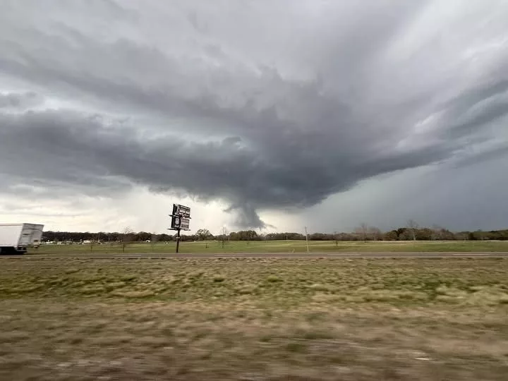
Photo: Tornado spotted near Parkers Crossroads last evening. Photo by Storm Chaser Adam Lucio.


